


What is DecaMaps?
DecaMaps is iPhone and iPad app to create a large detailed map that regular screenshot cannot handle it.
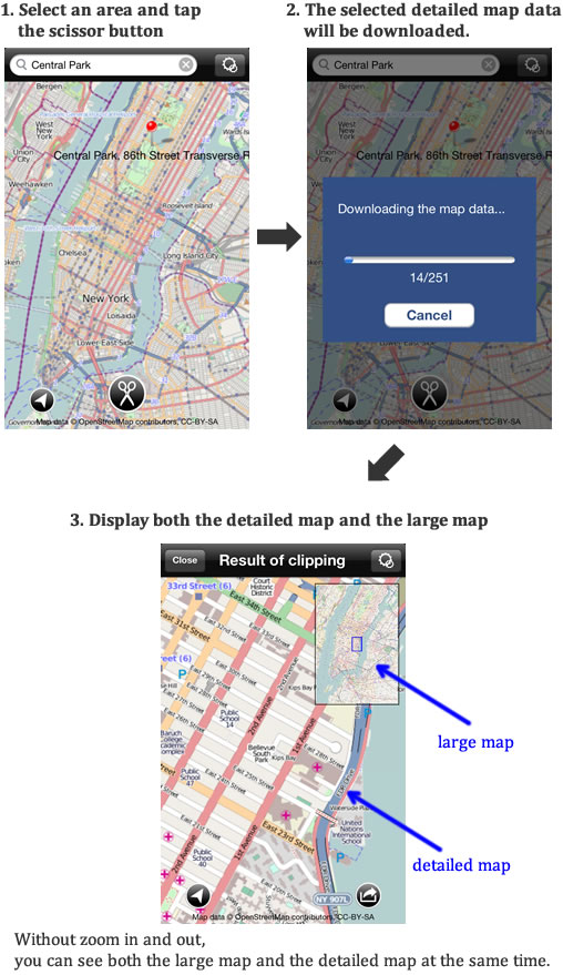
It is really easy operation. Select an area on the map and tap the scissor button.
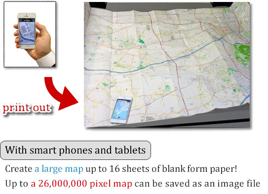
Up to 16 sheets of paper (4 sheets x 4sheets) can be printed out.
Regular print and 2 sheets print (1 sheet x 2sheets) functions are for free. Purchase an add-on if you want to print out a poster more than 4 sheets of paper.
How large is a map? Is it a detailed map?
DecaMaps can save a large map as an image file (up to 26,000,000 pixels).
How large is a map?
You can see an actual size of map image from the link below.

*DecaMaps displays a high-resolution image. Sometimes it takes a while to load a map data.
You can create a detailed large map and can print a poster print!
Operation movie
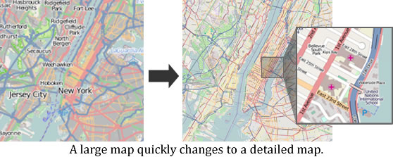
Select a necessary area on the map and cut it!
Easy operation! Select an area and tap the scissor button
The area you selected quickly becomes a large detailed map.
Print out a large map!
|
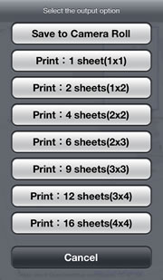
Tap the output button at a Result of clipping screen, you can select either “print” or “Save to Camera Roll”. You can print out a large poster up to 16 sheets of paper. Supported paper size: A4/Letter/B4/B5 printing method: 1 sheet, 2 sheets(1x2), 4 sheets(2x2), 6 sheets(2x3), 9 sheets(3x3), 12 sheets(3x4), 16 sheets(4x4) *Regular print and 2 sheets print (1 sheet x 2sheets) functions are for free. Purchase an add-on if you want to print out more than 4 sheets of paper. |
|
You can also save the map to Camera Roll.
Up to 26,000,000 pixel map can be saved as an image file.
*On specification of Camera Roll, saved image cannot zoom in enough, but the original image does not become depleted.
Save the image to your PC and view it or view with an iPhone app that supports with high resolution image
DecaMaps is a useful tool for checking your current location.
You can see your current location to your destination at a glance!
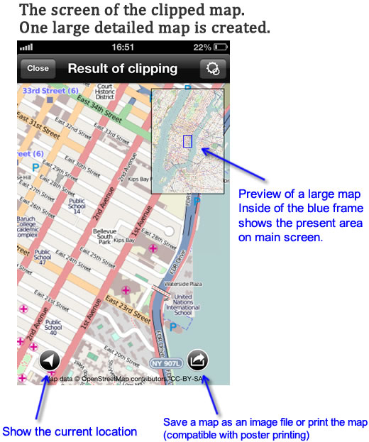
After clipped the map, DecaMaps displays zoomed in detailed map on the main screen and the entire clipped map on upper right corner. So you can see the both the detailed map and the large map at the same time.
e.g. Clip the travel area in advance, you see your current location to your destination at a glance.
Large map but never miss landmarks
In common map apps case, they omit landmarks to put in a large map on one screen. So user has to zoom in and out many times.
“DecaMaps” displays large and detailed map on the same screen, so you can check your current location and detailed landmarks simontaniously.
“DecaMaps” is useful for
If you print out a large map by yourself, it is very useful for below situations.
- Confirm the place where you have never been before
- For pre-confirmation of travel destination or use as a travel guidebook
(You can print out the same map as many as you want to, so write in with magic marker without hesitation.) - Print out the places where you have been to or have grown up and enjoy the sight of them
- For an evacuation map, an assistant return home map
- For checking a school route for your child/children
- For an event, a lecture presentation
DecaMaps adapts OpenStreetMap for map data.
Generally when you download map data, save it, or print out it, you need permission from copy right holders.
DecaMaps uses map information of OpenStreetMap’s license, so you can use these functions with a safe conscience.
※OpenStreetMap is a creating free map project which is free to everyone for geographical information data such as road map.
http://www.openstreetmap.org/
Future update schedule
We are scheduling to improve the current functions and adding new features below corresponding with the needs from market.
- improvement of search accuracy
- For hiking map, cycling map, writable print document and more useful styles
- Handwrite a route on a clipped map and adding marks and comments
- Saving bookmarks, managing bookmarks
Device compatibility/Price
Device compatibility:iPhone、iPod touch、iPad(iOS5.0 or later)
Price: free
*Free for printing posters less than 2 sheets of paper
*In app purchase is necessary for printing posters more than 4 sheets of paper (4/10/2014 – present $2.99)
*In app purchase is necessary for removing ads (4/10/2014 – present $0.99)
*To print posters, you need a printer that is compatible with
AirPrint and must be on the same Wi-Fi network.

Copyright © 2013 MEDIA NAVI,Inc. All Rights Reserved. |
 |